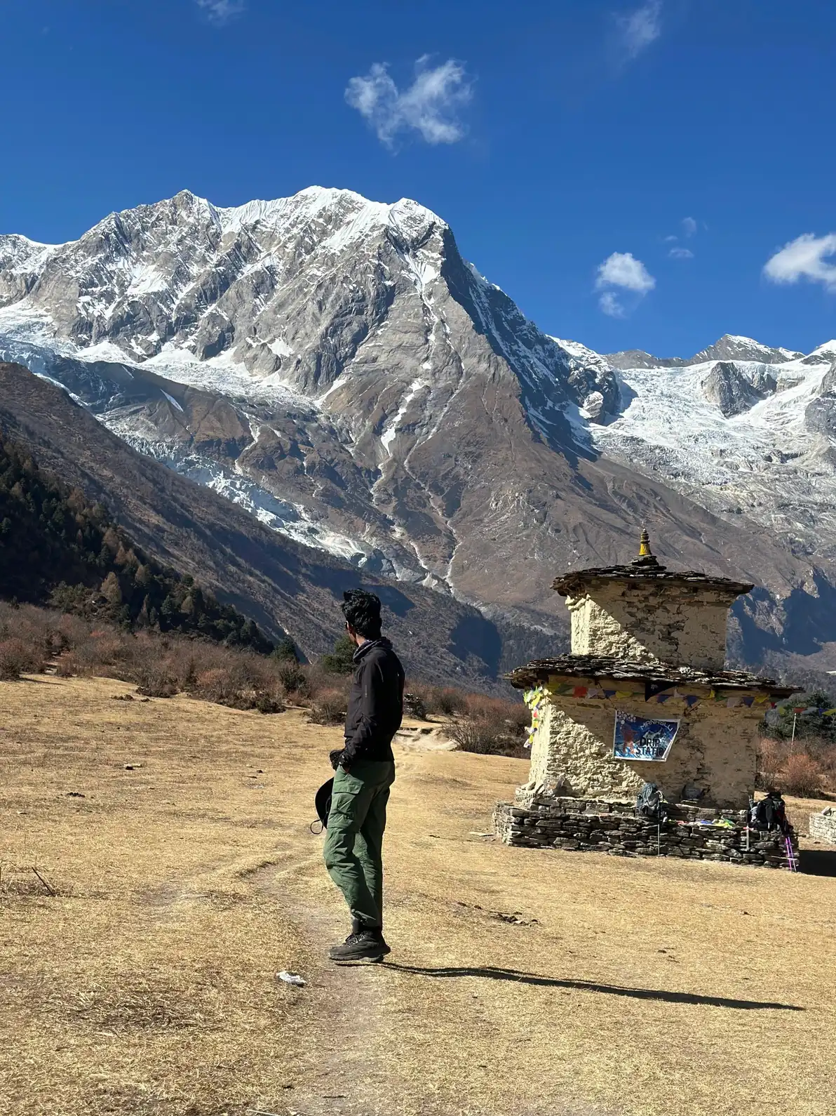
Manaslu Circuit
Manaslu Circuit with Rohit, a licensed local guide (#1497) with 5+ years on this route.
Manaslu Circuit at a glance
- Highest point
- 5,106m
- Days
- 12-14
- Best months
- Mar-May, Oct-Nov
- Difficulty
- Challenging
- Where
- Manaslu Conservation Area
- Starts from
- Kathmandu (via Soti Khola / Arughat)
- Getting there
- Drive from Kathmandu to Soti Khola or Arughat, 8 to 10 hours
- Permits
- Manaslu Restricted Area Permit (RAP)
- Manaslu Conservation Area Permit (MCAP)
- Annapurna Conservation Area Permit (ACAP)
- TIMS Card (Trekkers' Information Management System)
A restricted-area circuit around the world's eighth-highest mountain through remote Himalayan villages, crossing the Larkya La Pass at 5,106m with virtually none of the crowds found on nearby Annapurna routes.
Overview
The Manaslu Circuit is the trek I recommend when someone has done ABC or the Annapurna Circuit and wants something that feels genuinely different. The route encircles Mt. Manaslu (8,163m), the eighth-highest peak on earth, through a region that shares a cultural and linguistic world with Tibet rather than the Hindu lowlands. The restricted area permit requirement means the circuit never gets crowded, and the villages from Soti Khola to Samagaon have preserved a way of life that the more accessible Annapurna trails no longer show.
The trek begins in earnest from Soti Khola or Arughat, reached by road from Kathmandu, and follows the Budhi Gandaki river north through subtropical forest that gives way to increasingly arid, high-plateau terrain as you approach the Tibetan borderlands. Samagaun at 3,520m is the cultural and logistical heart of the route, a large Tibetan-influenced village with monasteries, yak herds, and a direct view of Manaslu's south face. I always build in a mandatory rest day here. Acclimatisation at Samagaun is not optional; the next sleeping altitude at Samdo (3,860m) and then the Larkya La (5,106m) cross require a properly adjusted body.
The pass crossing is the defining moment of the trek. You leave Dharmasala (4,460m) before dawn and climb steep, often icy terrain to the prayer-flag-festooned summit of Larkya La. The descent to Bimthang on the other side is long (over 1,600m of height loss in a single day) and legs are usually destroyed by the end. The circuit exits through the Annapurna Conservation Area past Dharapani, which means you also need an ACAP permit. A licensed guide is required by government regulation; since March 2026 solo trekkers can get the permit, arranged through a registered agency.
Who this trek is for
Experienced trekkers who have completed a moderate multi-day trek before and want a more remote, culturally rich experience. The Larkya La Pass crossing at 5,106m requires genuine fitness, altitude tolerance, and the willingness to spend 10+ hours walking in a single day. Government regulations require a licensed guide on this route. Since March 2026 you can trek it solo with a guide.
Best views & moments
- Crossing Larkya La Pass at 5,106m, one of the highest trekking passes in Nepal, often with ice and snow
- Samagaun village at 3,520m: Tibetan-influenced stone houses, gompas, and Manaslu's south face directly ahead
- Walking the Budhi Gandaki gorge through subtropical forest, waterfalls, and hanging bridges
- Almost no crowds: the restricted area permit keeps daily trekker numbers low year-round
- Ancient Buddhist monasteries at Pungyen Gompa and Mu Gompa near Samagaun
- Views of Manaslu, Himalchuli, Ganesh Himal, and Annapurna II from the circuit
- The Tibetan-influenced architecture and dress of villages from Namrung to Samdo
- Remote camping atmosphere despite teahouse infrastructure: no day-trippers, no noise
Day-by-day itinerary
Long drive from Kathmandu to Soti Khola (or Arughat), the trailhead village on the Budhi Gandaki. The road varies in quality; expect 8-10 hours depending on season and stops. Overnight in basic guesthouse at the river.
Trek begins along the Budhi Gandaki through rice terraces, small settlements, and subtropical riverine forest. Suspension bridges and riverside trail. Relatively gentle walking to warm up. Around 5-6 hours.
The valley narrows considerably. Trail climbs above the river through denser forest, crossing several tributaries. Jagat is a checkpoint village where permits are inspected. The restricted area begins here. Around 6 hours.
The gorge deepens and the landscape begins its transition from subtropical to temperate. The Budhi Gandaki cuts through rock sections requiring suspension bridge crossings. Stone villages become more frequent. Around 6-7 hours.
Altitude becomes noticeable. The cultural character shifts visibly as Tibetan-style stone buildings and chortens appear. Prayer walls line the trail. The walking pace slows compared to the lower gorge, and correctly so. Around 6 hours.
First clear views of Manaslu's main massif above the treeline. Lho is a scenic village with a strong monastery and panoramic views north. The terrain is more open. Around 4-5 hours, deliberately short to allow altitude adjustment.
The valley broadens into a wide glacial plain. Samagaun is the largest village on the circuit: teahouses, a health post, a monastery, and direct views of Manaslu's south face and the Manaslu glacier. Around 4-5 hours.
A mandatory rest and acclimatisation day. I always use this day for a hike toward Manaslu Base Camp (4,480m) or Pungyen Gompa: high hiking, low sleeping. The altitude gain to Larkya La the next two days requires a well-rested body. Do not push through this rest day.
Short day to the remote village of Samdo at 3,860m, close to the Tibetan border. The terrain is treeless, high-altitude plateau. Views of Samdo Peak and surrounding glaciated summits. Good afternoon for resting and hydrating. Around 3-4 hours.
Another short, important day: acclimatisation before the pass. Dharmasala at 4,460m is a basic high-camp stop with limited teahouse facilities. The air is thin, nights are cold, and sleep may be difficult. Early to bed is essential. Around 3-4 hours.
The biggest day on the circuit. Depart well before dawn (3-4am is typical) to cross Larkya La before afternoon clouds and wind build. The final approach to the pass is steep, often icy, and above 5,000m the going is slow. The pass itself at 5,106m offers vast mountain panoramas. The descent to Bimthang is long (1,600m down) and leg-destroying. Around 9-10 hours total.
A long descent back into the Annapurna Conservation Area. The forest returns below 2,500m and the air feels thick again. Dharapani is a larger village with good food and comfortable teahouses. Around 6-7 hours.
Short morning trek to Besi Shahar, then jeep or bus to Kathmandu, a long drive of 6-8 hours depending on road conditions. The circuit is complete. If time and legs allow, Pokhara is an alternative endpoint.
Route & terrain
The Manaslu Circuit follows the Budhi Gandaki river from the roadhead at Soti Khola or Arughat northward through a dramatic gorge that transitions from subtropical rice-terrace country to high-altitude Tibetan plateau over roughly five days of walking. The gorge section is genuinely remote, narrow enough that sunlight only reaches the valley floor for a few hours each day, with suspension bridges, waterfalls, and dense forest pressing in on both sides.
From Namrung upward the character of the route changes completely. Stone mani walls line the trail, chortens mark every ridge spur, and the villages of Lho, Shyala, and Samagaun have the flat-roofed, wind-braced architecture of the Tibetan highlands. Samagaun at 3,520m is the hub of the upper circuit. From here you can see Manaslu's south face clearly and the route to both the base camp and the Larkya La is visible.
The pass crossing from Dharmasala to Bimthang is the physical and psychological centrepiece of the trek. The climb from the 4,460m camp to the 5,106m pass takes 3-4 hours in thin air on rocky, often snow-covered terrain. The descent on the far side drops 1,600m to Bimthang and another 1,700m to Dharapani the following day. The circuit exits through the Marsyangdi valley into the Annapurna Conservation Area, ending at Besi Shahar for the road connection back to Kathmandu or Pokhara.
General info
Difficulty & preparation
The Manaslu Circuit is rated Challenging and earns that rating in two specific places: the sustained high-altitude walking across multiple days above 3,500m, and the Larkya La crossing itself. Daily walking time runs 5-7 hours on most days, with the pass crossing day requiring 9-10 hours from a 3-4am start.
The terrain varies considerably. The lower gorge (Soti Khola to Deng) involves rocky riverside trail with frequent bridge crossings and is not technically difficult but is unrelentingly steep in sections. The middle section (Deng to Namrung) adds altitude to the physical load. Above Namrung the trail is on open high-altitude terrain with loose rock and potential for snow.
The Larkya La approach from Dharmasala involves steep rocky and often icy slopes at and above 5,000m. Trekking poles and traction aids (microspikes or crampons in season) are strongly advised. Physical fitness needs to be higher than for ABC or the Poon Hill circuit. Specifically, cardiovascular capacity at altitude matters more than pure leg strength, because the cumulative days of walking at 3,500-4,500m deplete reserves that low-altitude training cannot fully replicate. Previous multi-day high-altitude trekking experience is genuinely recommended.
How to prepare
Begin cardiovascular training 10-12 weeks before departure for the Manaslu Circuit. The circuit accumulates more total altitude gain than ABC and requires sustained output over 12-14 consecutive days. Running, cycling, and hiking with a loaded pack are all relevant. The goal is being able to walk 6-7 hours daily without the last two hours becoming a survival exercise.
High-altitude experience from a previous trek helps calibrate your acclimatisation response. If this is your first time above 4,000m, consider whether a shorter introduction at altitude before Manaslu would be wise. Even a week at the ABC or Langtang level teaches you how your body handles thin air. For Manaslu specifically, the acclimatisation rest day at Samagaun (3,520m) and the short day to Samdo (3,860m) are built into the itinerary for good reason; I will not shorten them.
Carry acetazolamide (Diamox) prescribed by your doctor. It can help prevent altitude sickness, but it is no substitute for a slow ascent, so talk it through with your doctor before the trip. Know the AMS symptoms cold. On a restricted-area trek with no quick road access, early recognition and descent are more important than on accessible routes. Travel insurance that explicitly covers emergency helicopter evacuation from a restricted area is not optional.
Permits you'll need
Manaslu Restricted Area Permit (RAP)
USD 100 for the first week, then USD 15/day (Sep-Nov); USD 75 for the first week, then USD 10/day (Dec-Aug)
The most significant permit, mandatory for the restricted zone from Jagat to Samagaun and the pass. Must be obtained through a registered trekking agency. Cannot be obtained by individuals.
Manaslu Conservation Area Permit (MCAP)
NPR 3,000 (foreigners) / NPR 1,000 (SAARC nationals) per person
Required for all foreign nationals entering the Manaslu Conservation Area.
Annapurna Conservation Area Permit (ACAP)
NPR 3,000 (foreigners) / NPR 1,000 (SAARC nationals) per person
Required because the circuit exits through Dharapani and Besi Shahar, which fall within the Annapurna Conservation Area.
TIMS Card (Trekkers' Information Management System)
NPR 2,000 (foreigners) / NPR 1,000 (SAARC nationals) per person
Required when passing through the Annapurna Conservation Area section of the route.
I handle all permit paperwork as your licensed guide.
Altitude & acclimatisation
The Manaslu Circuit spends more time above 3,500m than most other popular treks in Nepal, which is its key altitude risk factor. The sleeping altitude sequence is: Namrung 2,630m, Lho 3,180m, Samagaun 3,520m, Samdo 3,860m, Dharmasala 4,460m. The jump from Samdo to Dharmasala (600m gain in a short day) followed by the pass crossing to Bimthang (5,106m summit, 3,590m sleep) is the most extreme segment.
I carry a pulse oximeter on every Manaslu trek and check readings at Samagaun, Samdo, and Dharmasala. A resting SpO2 below 78% at Samagaun or below 72% at Dharmasala, combined with symptoms, warrants descending rather than continuing. The mandatory acclimatisation day at Samagaun and the short day to Samdo are the insurance against rushing this segment.
The high-altitude exposure on the pass crossing day is the greatest individual AMS risk: spending several hours above 5,000m in cold, often windy conditions while physically exerting. Anyone who shows HACE symptoms (confusion, inability to walk straight) or HAPE symptoms (shortness of breath at rest, persistent cough) on the pass must descend immediately regardless of how close the far side is. Helicopter evacuation from the Manaslu region is possible but requires clear weather and a landing zone. Bimthang and Samagaun are the main options.
Food & accommodation
The teahouse standard on the Manaslu Circuit is lower than the Annapurna routes, which is part of what makes it feel genuinely remote. In the lower gorge (Soti Khola to Deng), guesthouses are basic but functional. From Namrung upward the rooms are typically wooden boards, thin mattresses, and communal toilets. Above Samdo, Dharmasala is the most basic stop, a handful of teahouses with very limited menu options and cold conditions even in October.
Food quality on the circuit is honest rather than elaborate. Dal bhat is reliable and filling everywhere. Noodle soup, potato dishes, and eggs round out most menus in the higher villages. Some teahouses in Samagaun offer Tibetan bread and butter tea, worth trying even if you adjust the seasoning. Alcohol is available but I advise against it above 3,000m. Carry electrolyte tablets and high-calorie trail snacks. The calorie deficit across 12 days at altitude is real and teahouse portions are not always large enough to compensate.
What to pack
The Manaslu Circuit is colder and more remote than ABC. Teahouses exist throughout but they are simpler, especially above Namrung. Expect thin walls, few electrical sockets, and cold nights even in October. Your sleeping bag should be rated to -15°C for the Larkya Base Camp night at 4,460m.
Specific to this route: bring trekking poles. Both the gorge section and the Larkya La descent make them essential, not optional. Traction devices (microspikes or lightweight crampons) are strongly advised for the pass crossing in spring and autumn when the upper slopes can be icy. A down jacket rated for sub-zero temperatures is necessary from Namrung upward. Layering is the right approach: thermal base layer, fleece mid-layer, and a waterproof shell for the pass.
Carry more emergency snacks than you think you need. The pass crossing day burns an enormous number of calories and teahouse meals at Dharmasala are basic. A thermos or insulated bottle helps keep water from freezing overnight at Dharmasala and on the pass approach. Power banks are important as charging becomes unreliable above Samagaun.
Frequently asked questions
The Government of Nepal designates the Manaslu region as a restricted area, and the permit conditions require all foreign trekkers to be accompanied by a licensed guide, with the trip arranged through a registered agency. Since March 2026 the two-person minimum no longer applies, so solo trekkers can go with a guide. Beyond the regulation, a guide genuinely matters here. The route above Namrung is remote, the pass is serious, and local knowledge of weather patterns and teahouse availability is valuable. I have a Nepal Tourism Board license (NTB #1497) and have crossed Larkya La multiple times.
For a 13-day trek in peak season (October-November), the main permit costs are: Restricted Area Permit USD 130 (USD 100 for the first week plus USD 15 a day after that), MCAP NPR 3,000, ACAP NPR 3,000 and TIMS NPR 2,000. That comes to roughly USD 190 per person in high season and about USD 155 in the off-season (December-August, when the permit is USD 75 for the first week plus USD 10 a day). All permits must be arranged through a registered agency.
In the main trekking seasons of October-November and March-May, the pass is normally crossable but conditions vary year to year. Heavy snowfall can close it temporarily even in peak season. In winter (December-February) the pass has deep snow and is dangerous without proper mountaineering equipment and experience. In monsoon (June-September), landslide risk below the pass is high and most operators do not run the circuit. I monitor pass conditions through contacts in Samagaun before committing to the crossing.
There is no separate Chumnubri fee: the Manaslu Restricted Area Permit covers wards 1-4 of Chumnubri Rural Municipality. The Tsum Valley side trip (wards 3, 6 and 7) needs its own permit: USD 40 for the first week plus USD 7 a day (September-November), or USD 30 for the first week plus USD 7 a day (December-August). Your agency arranges both.
Yes, and it is a genuinely excellent combination. Tsum Valley branches north from the main circuit near Jagat and requires a separate restricted area permit (USD 40 per week in high season). Adding Tsum Valley extends the trek to 18-22 days total. The valley is even more remote and culturally intact than the main circuit, with ancient Tibetan Buddhist villages and very few visitors. I run this combination and consider it one of the best extended treks in Nepal.
You need to be in strong aerobic condition and comfortable with long mountain days. The Larkya La crossing involves 9-10 hours of walking with roughly 650m of ascent and 1,600m of descent, at altitudes between 4,460m and 5,106m. By the time you reach the pass, your legs have already accumulated 10+ days of trail fatigue. If you can run 5km without stopping, hike for 5 hours with a pack, and have some prior high-altitude experience, you are in the right range.
Sources & references
- https://www.mountgloryadventures.com/blog/manaslu-trek-permit-and-cost
- https://himalayanhero.com/manaslu/package/manaslu-circuit-trek/
- https://mountgloryadventures.com/blog/manaslu-trek-permit-and-cost
- https://followalice.com/knowledge/nepal-trekking-permits-and-fees
- https://adventurealtitudetreks.com/manaslu-circuit-trek
Ready to book Manaslu Circuit?
Licensed guide #1497, 5+ years guiding this route. Plan every detail directly with Rohit.