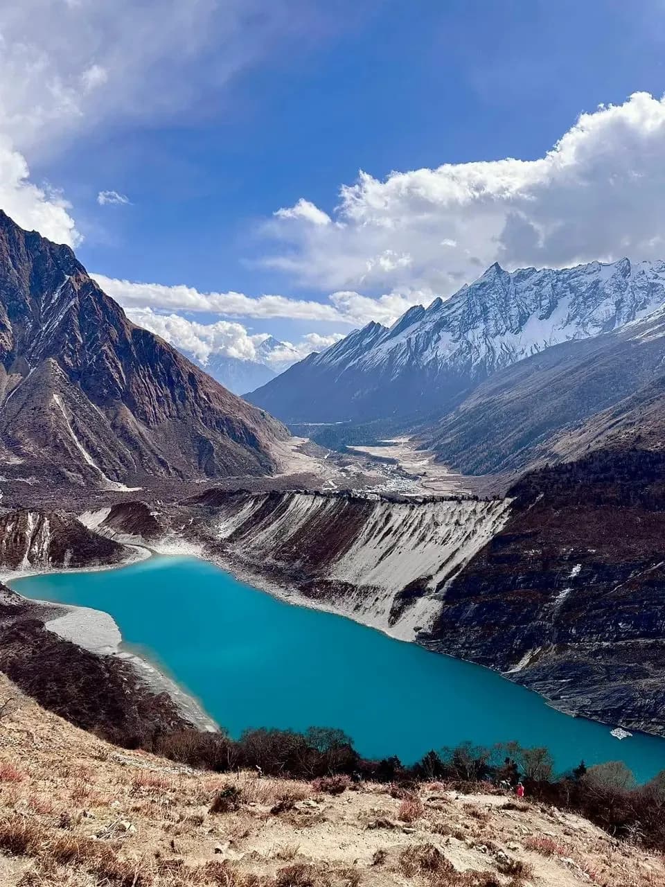
Tilicho Lake
Tilicho Lake with Rohit, a licensed local guide (#1497) with 5+ years on this route.
Tilicho Lake at a glance
- Highest point
- 4,919m
- Days
- 10-14
- Best months
- Mar-May, Oct-Nov
- Difficulty
- Challenging
- Where
- Annapurna Conservation Area
- Starts from
- Pokhara
- Getting there
- Drive from Pokhara to Besishahar, then jeep to Chame, about 6 to 8 hours
Trek deep into the Annapurna Circuit to reach Tilicho Lake at 4,919m, one of the highest lakes in the world, on a route that combines the classic Marsyangdi valley with a demanding high-altitude detour into a glacial bowl.
Overview
Tilicho Lake sits at 4,919m in a glacial cirque beneath the Tilicho Peak massif, and reaching it is a serious undertaking. The approach follows the Annapurna Circuit route up the Marsyangdi valley from Besishahar through Chame and Pisang to Manang (a beautiful walk through pine forest, apple orchards, and high-desert plateau country) before branching off to the dedicated lake trail. The lake itself is about 5km long at altitude, framed by the vertical ridgelines of the Great Barrier, and the colour of the water on a clear day is a specific shade of deep blue-grey that I have not seen replicated anywhere else in Nepal.
The route requires careful acclimatisation. Manang at 3,540m is the mandatory overnight before any attempt on the lake approach, and I always add a full rest day there for side hikes to Gangapurna Lake and the Himalayan Rescue Association's altitude briefing. The lake camp at approximately 4,150m is the jumping-off point for the final climb to 4,919m, a section that involves steep, loose scree and a glacier margin traverse. The conditions on this final section change with season: in spring there is residual snow that makes footing better but increases avalanche risk from the slopes above; in autumn it is drier but the loose gravel is more treacherous.
This is not just a lake detour bolted onto the Annapurna Circuit. It is a serious objective in its own right. I plan the itinerary with the lake as the primary goal and the Annapurna valley scenery as the approach, rather than treating it as a side trip. After Tilicho the options are to return to the circuit and continue over Thorong La, or to descend back through Manang and exit via Besishahar. I typically take 12-14 days to do it properly.
Who this trek is for
Fit trekkers who have ideally completed one high-altitude trek before and want a serious objective above 4,900m. The traverse above the Great Barrier to Tilicho Base Camp is the most technically demanding section (narrow, exposed, and loose) and requires confident footing and a good head for heights. Anyone with a fear of exposed traverses should know this before committing. The acclimatisation approach via the Annapurna Circuit valley adds days but is necessary and beautiful.
Best views & moments
- Tilicho Lake at 4,919m: a vast, still, high-altitude glacial lake beneath the Tilicho massif
- The approach traverse above the Great Barrier with sheer 1,000m+ drops on one side
- Manang valley plateau at 3,540m: apple orchards, painted monastery walls, mountain backdrop
- Gangapurna Glacier Lake visible from Manang on the acclimatisation afternoon
- The Marsyangdi valley walk through Chame and Pisang: pine forest, waterfalls, and red-rock canyon
- Traditional Manangi villages with flat-roofed stone houses and Tibetan Buddhist influence
- Himalayan Rescue Association altitude briefing in Manang (genuinely useful, not a tourist attraction)
- Crossing the high-altitude trail between Khangsar and Tilicho Base Camp with Annapurna III visible ahead
Day-by-day itinerary
Drive from Pokhara to Besishahar then continue by jeep up the Marsyangdi valley to Chame. The road follows the river gorge through a landscape of terraced fields and pine forest. Chame is a proper town with good facilities and a checkpoint. Around 6-8 hours driving.
The trail climbs through pine and fir forest above the Marsyangdi gorge. A large natural rock overhang and the first views of the Annapurna range mark the upper section. Upper Pisang sits on a ridge with panoramic mountain views that announce you are genuinely in the high Himalayas.
One of the most scenic days of the circuit: the trail traverses the upper valley above the river with views of Annapurna II, III, and IV and Gangapurna. Manang is a large village with the feel of a highland market town. The altitude at 3,540m is where acclimatisation becomes critical.
Rest day. Do not actually rest. The standard approach is a hike to Gangapurna Lake (3,700m) in the morning and the Himalayan Rescue Association's free AMS briefing in the afternoon. Walking high and sleeping low on this day is the foundation for the Tilicho approach. Essential, not optional.
Short day west on a jeep track to the village of Khangsar (3,734m), the last real settlement before the lake trail. Good afternoon to rest and prepare for the demanding days ahead. Views north toward Tilicho Peak and the Great Barrier ridgeline.
The trail climbs above the treeline onto a high traverse above the Great Barrier cliffs: a narrow, exposed path with significant drop on the south side and steep slopes above. Tilicho Base Camp sits in a glacial bowl at approximately 4,150m with teahouse accommodation. Around 5-6 hours.
Early start for the push to Tilicho Lake at 4,919m. The route climbs steeply over loose scree and glacial moraine with some snow in spring. At the lake, the scale is extraordinary: 5km of still, dark water in a glacial cirque. Return to base camp the same day. Around 5-7 hours round trip.
Retrace the traverse route back to Khangsar then continue to Manang. The downhill feels earned. Good teahouse meals and a proper bed in Manang after the high-altitude exertion.
Continue up the Annapurna Circuit toward Thorong La, ascending to Yak Kharka at 4,018m. The terrain is open, treeless, and cold. Grazing yaks are common. Short day to allow altitude adjustment before the high camps.
Short final approach to Thorong Phedi (4,540m) or the High Camp above (4,925m). If continuing over Thorong La the following day, High Camp is preferable despite the basic conditions. If exiting back to Besishahar, stop at Phedi.
If continuing the full Annapurna Circuit: cross Thorong La (5,416m) to Muktinath (3,760m), an 8-9 hour day. If exiting at Tilicho only: descend via Besishahar. The pass crossing adds immensely to the trip for those with the fitness and schedule.
Drive or walk down the Kali Gandaki valley to Jomsom, then take the morning flight to Pokhara (30 minutes). The flight is the most efficient exit; the road is long. Trek complete.
Route & terrain
The Tilicho Lake trek begins with the lower Annapurna Circuit approach, following the Marsyangdi river valley north from Besishahar through successive altitude bands: subtropical forest at Bhulbhule, pine and rhododendron at Chame, and the dry, high-elevation plateau terrain around Pisang and Manang. This approach covers roughly 4-5 days before the lake-specific route begins.
From Manang the route diverges west from the main circuit to the village of Khangsar, and from here the character of the trek changes completely. The trail climbs above the Great Barrier on a narrow shelf with serious exposure on one side. This section requires care and focus, particularly if wet or icy. The Tilicho Base Camp at approximately 4,150m is a cluster of teahouses in a glacial bowl; above it the final climb to the lake at 4,919m involves steep scree and potential glacier ice.
The return route options are to retrace to Manang and continue over Thorong La on the main circuit (extending the trip by 2-3 days), or to descend back through Besishahar for road transport to Pokhara. The combination of Tilicho Lake and Thorong La in a single itinerary gives one of the most complete high-altitude experiences available in Nepal, covering two objectives above 4,900m in consecutive days.
General info
Difficulty & preparation
The Tilicho Lake trek is Challenging, primarily due to two sections: the exposed traverse above the Great Barrier between Khangsar and Tilicho Base Camp, and the final climb to the lake at 4,919m on loose scree and potential snow. Neither section involves ropes or technical climbing, but both demand confident footing on steep, exposed terrain at altitude.
Daily walking hours range from 4 hours on the acclimatisation and short approach days to 8-9 hours on the lake attempt day (round trip from base camp). The altitude accumulation is substantial. The route spends multiple nights above 3,500m and the lake sits nearly 1,400m above the Manang acclimatisation stop. The Marsyangdi valley approach days (Besishahar to Manang) are moderate by comparison but still involve 1,200m of total elevation gain over three walking days.
The Great Barrier traverse is the section I brief people most carefully on. The trail is narrow, sometimes a metre wide, with a steep drop into the valley below and scree slopes above. It is not technically difficult in good conditions but it demands attention and can be genuinely dangerous if wet or icy. Good trekking boots with ankle support are non-negotiable; trekking poles are essential on the traverse and the lake climb.
How to prepare
Prepare for the Tilicho Lake trek with the same base fitness as you would for a high-altitude pass crossing: sustained cardiovascular training over 10-12 weeks, with emphasis on hiking with a loaded pack. The lake at 4,919m is only 200m lower than Thorong La, and the exposed traverse to get there demands both fitness and stability of foot.
The acclimatisation profile built into the itinerary is adequate if followed correctly. The key discipline is not skipping the rest day in Manang and not rushing from Manang to Tilicho Base Camp in a single day. The altitude gain is too fast. The base camp night at 4,150m is the acclimatisation platform for the lake push, and arriving there tired and underhydrated sets up a harder day.
For the traverse section specifically: if you have vertigo or strong anxiety about exposed trails, train on this before departure: hike ridge trails that involve some exposure and assess your reaction. The Great Barrier traverse is not the place to discover this about yourself for the first time. Pack gaiters for spring when residual snow is present on the approach. Carry Diamox prescribed by your doctor and know the AMS symptoms.
Permits you'll need
Annapurna Conservation Area Permit (ACAP)
NPR 3,000 (foreigners) / NPR 1,000 (SAARC nationals) per person
Required for the entire Annapurna Circuit and Tilicho Lake route. Obtainable in Pokhara or Kathmandu at the Nepal Tourism Board.
TIMS Card (Trekkers' Information Management System)
NPR 2,000 (foreigners) / NPR 1,000 (SAARC nationals) per person
Required for all trekkers in the Annapurna region.
I handle all permit paperwork as your licensed guide.
Altitude & acclimatisation
Tilicho Lake at 4,919m is one of the highest lake objectives in Nepal, and the altitude profile of this route is among the most demanding on the Annapurna circuit. The sleeping altitude sequence is: Chame 2,710m, Upper Pisang 3,310m, Manang 3,540m (two nights), Khangsar 3,734m, Tilicho Base Camp 4,150m, lake push to 4,919m. The jump from two acclimatisation nights at 3,540m to sleeping at 4,150m is the critical step.
I use the acclimatisation day in Manang (day four) specifically to go high. The Gangapurna Lake hike to 3,700m is exactly the right 'climb high, sleep low' stimulus before continuing. Anyone who reports headache or nausea on the morning after arriving in Manang gets an extra day before we move.
The lake itself is visited as a day-hike objective from base camp. You do not sleep at 4,919m. The round trip from base camp involves roughly 770m of altitude gain and the same on descent. Acclimatisation at base camp the night before is important; pushing from Manang or Khangsar directly to the lake in a single day is possible but significantly higher risk.
Food & accommodation
The lower Annapurna Circuit section (Besishahar to Manang) has well-established teahouses with a wide menu, charging facilities, and reasonable comfort. Manang itself is a good-sized village with bakeries, gear shops, and several teahouses with proper heating. This is the best-provisioned part of the route.
Tilicho Base Camp is significantly more basic: a handful of teahouses with limited menu options. Dal bhat, potato dishes, noodle soup, and eggs are the reliable choices. Fresh vegetables are scarce at this altitude. The teahouses have blankets but they are not warm, and the dining rooms are cold. Hot tea and warm soup are your best friends at base camp altitude.
Between Manang and base camp via Khangsar there is one teahouse at Khangsar itself. Carry lunch snacks for the traverse day. The acclimatisation day in Manang is also a good opportunity to buy any last-minute supplies (chocolate, nuts, electrolyte tablets) before heading up to the higher camps.
What to pack
Tilicho Base Camp teahouses are the most basic accommodation on this route: wooden structures at 4,150m with thin insulation. Your sleeping bag must be rated to -15°C. A warm down jacket is essential from Manang upward and mandatory at base camp and on the lake push.
Specific gear for the traverse: gloves are important even in October as the traverse is exposed and wind-cut. Good quality trekking poles with wrist straps give stability on the narrow sections. Traction aids (microspikes) are useful in early spring and late autumn when the upper trail can be icy. A trekking helmet is not required but people who know they are nervous about loose rock overhead sometimes choose to wear one.
Sun protection at this altitude is serious. SPO2 at 4,900m is significantly lower than at sea level, and the UV exposure is intense. High-factor sunscreen, UV-blocking sunglasses, and a brimmed hat are not optional. Carry 3-4 litres of water capacity; there is a refill point at base camp but none between the traverse start at Khangsar and the camp arrival.
Frequently asked questions
It is one of the highest, but not strictly the highest. Tilicho sits at 4,919m and is listed in various sources as the world's highest lake at significant scale, but there are smaller glacial tarns and crater lakes above this altitude in other parts of the world. The Guinness Book previously listed Tilicho as the highest lake in the world by area. Whatever the exact ranking, it is an extraordinary place. The scale, the altitude, and the mountain surroundings are unlike anything on a standard trekking route.
Yes, and this is how most people approach it: you follow the main Annapurna Circuit route to Manang, take the Tilicho detour (adding 2-3 days), return to Manang, and continue over Thorong La. This is the most efficient use of time for a 14-16 day trip. The detour adds 2-3 days to a standard Annapurna Circuit. If Tilicho Lake is your primary objective and you are short on time, it is also possible to approach specifically for the lake without crossing Thorong La.
The traverse above the Great Barrier is the most exposed section on this route. The trail is narrow, as little as a metre wide in places, with a serious drop into the valley below and loose scree slopes above. There have been incidents involving falling rock. It is not technically difficult in good conditions, but you need to be comfortable on exposed mountain trails and confident in your footwork. In wet or icy conditions the risk increases significantly. I brief every group on this section specifically before we start.
October is ideal: the lake is unfrozen, the skies are typically clear, the mountain views are excellent, and the trail conditions are stable. April-May is also good and has the advantage of rhododendron on the lower trail, though there may be residual snow on the lake approach. The lake freezes in winter (December-February) and is inaccessible. Monsoon season (June-September) brings heavy precipitation, landslide risk, and poor visibility. Not viable.
The Annapurna Conservation Area currently allows independent trekking without a mandatory guide (unlike Manaslu or Upper Mustang). However, the Tilicho traverse is genuinely more complex than the main circuit, and solo navigation in poor weather or snow conditions is risky. I would strongly encourage at least a guide for the base camp and lake section, even if trekking independently on the lower valley. The route between Khangsar and base camp can be confusing in cloud or snow.
Yes, and it is one of the best combinations in the Annapurna region. After visiting Tilicho Lake and returning to Manang, continue up the main circuit to Yak Kharka, High Camp, and cross Thorong La (5,416m) to Muktinath. This adds 2-3 days and creates an itinerary that visits two objectives above 4,900m. The total trip runs 14-18 days. You need the fitness for both, since the lake and the pass occur within 4-5 days of each other at sustained altitude.
Sources & references
Ready to book Tilicho Lake?
Licensed guide #1497, 5+ years guiding this route. Plan every detail directly with Rohit.