Quick facts
Fly from Kathmandu to the legendary Lukla airstrip and walk through the Sherpa heartland of Khumbu to Everest Base Camp at 5,364m — one of the world's great high-altitude treks.
Overview
Everest Base Camp is the trek I get asked about more than any other. People want to stand at the foot of the world's highest mountain, and this is one of the few high-altitude routes on earth where a fit, determined trekker with no technical climbing skill can legitimately do so. The approach through the Khumbu valley is not a scramble through wilderness — it moves through living Sherpa communities, past ancient gompas, and alongside yak trains on stone-paved trails that have served this region for centuries.
The route begins with a flight from Kathmandu to Lukla's Tenzing-Hillary Airport at 2,840m — twelve minutes in a small aircraft over a sea of ridgelines. From Lukla you follow the Dudh Kosi river north through Phakding and up the stiff climb to Namche Bazaar at 3,440m, the commercial and cultural hub of the Khumbu. Namche deserves a full rest day for acclimatisation: the Everest View Hotel hike and the Saturday market are both worth your morning. Above Namche the trail passes Tengboche Monastery at 3,860m — the most dramatic monastery setting I have seen in all of Nepal — before descending into the Imja Khola valley and climbing to Dingboche at 4,410m.
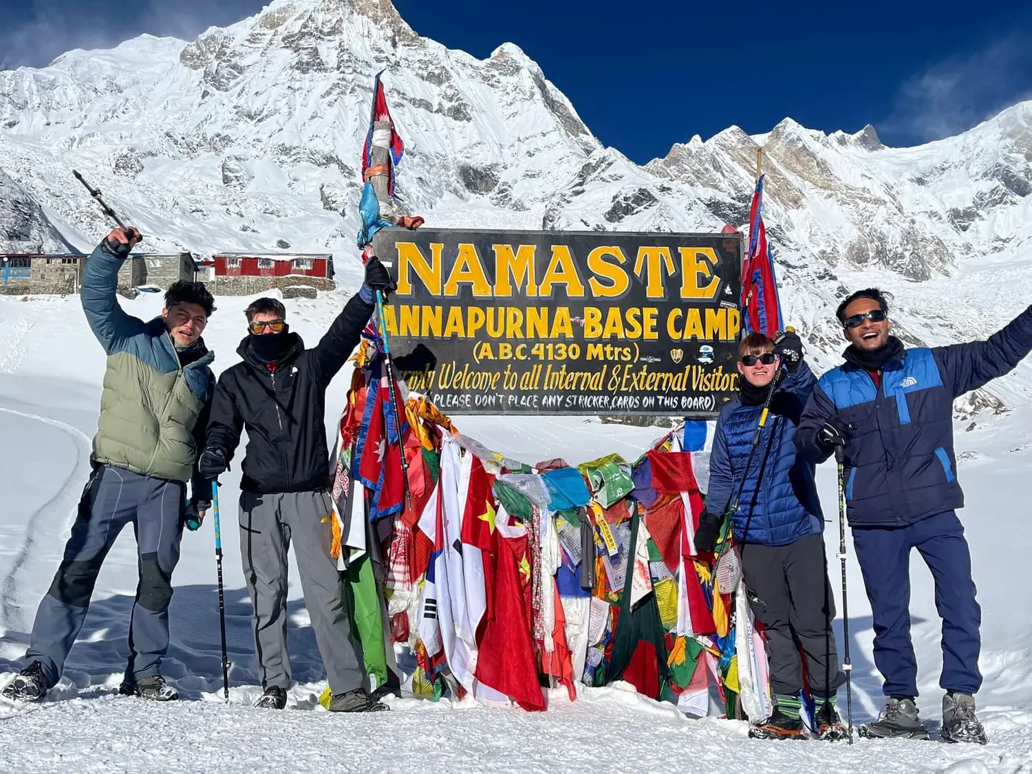
A second acclimatisation day at Dingboche is not optional — it is the cornerstone of reaching base camp safely. I use that day for a hike to the Nagarjun Hill or Chhukung Ri ridge above town, which pushes the body to around 5,000m before sleeping low again. Above Dingboche the landscape empties: Lobuche at 4,940m, then Gorak Shep at 5,164m, which is the last teahouse settlement before base camp. The final walk to Everest Base Camp at 5,364m crosses lateral moraine and glacial debris on the Khumbu Glacier — it is not technically demanding but the altitude slows everything to a deliberate pace.
I always include the pre-dawn hike to Kala Patthar at 5,545m above Gorak Shep. From that black-rock summit Everest's south face fills the sky in a way it simply does not from base camp itself, which sits in a bowl below the Khumbu Icefall. On a still morning in October it is among the most extraordinary views I have experienced as a guide. The return to Lukla takes three days of descent, and I generally fly clients back to Kathmandu the same afternoon they arrive in Lukla.
Who this trek is for
Fit trekkers who can sustain 5-7 hours of walking per day at altitude for nearly two weeks. No technical climbing is required — this is a walking trek on established trails. Prior high-altitude experience above 3,500m is a genuine advantage but not mandatory if pre-trip fitness is strong. Anyone with a history of severe altitude sickness, heart conditions, or respiratory issues should consult a doctor before committing. The mental challenge of remoteness and cumulative fatigue is as real as the physical one.
Best views & moments
- Standing at Everest Base Camp (5,364m) on the Khumbu Glacier at the foot of the highest mountain on earth
- Kala Patthar summit (5,545m) at dawn — Everest's south face, the Lhotse wall, and the entire Khumbu in one sweep
- Tengboche Monastery at 3,860m with Ama Dablam rising directly behind — the iconic Khumbu photograph
- Acclimatisation hike from Dingboche to Chhukung Ri, reaching ~5,000m and looking into the Imja Khola valley
- Namche Bazaar Saturday market — Sherpa traders, expedition gear, fresh apple pie, and the clearest mountain-town energy in Nepal
- The Dudh Kosi gorge walk from Lukla to Namche through rhododendron and pine, crossing high suspension bridges above river rapids
- Yak caravans on the trail above Dingboche, moving loads to base camp with the Lhotse face as backdrop
- The complete Khumbu panorama from the Namche viewpoint hike: Everest, Lhotse, Nuptse, Ama Dablam, Thamserku in a single frame
Day-by-day itinerary
Route & terrain
The Everest Base Camp trek begins with a 35-minute flight from Kathmandu's Tribhuvan Airport to Lukla's Tenzing-Hillary Airport at 2,840m — one of the world's shortest and most dramatic runways, perched on a mountain shelf in Solukhumbu district. From Lukla the trail descends into the Dudh Kosi gorge and follows the river north through rhododendron and pine forest, crossing a series of high suspension bridges to Phakding before the hard 600-metre climb to Namche Bazaar at 3,440m.
Namche is the commercial capital of the Khumbu — a horseshoe-shaped town filled with bakeries, gear shops, wifi cafes, and the Sherpa culture museum. A mandatory acclimatisation day here allows the body to begin adjusting to real altitude before the route continues. Above Namche the trail traverses a high contour path past Kunde and Khumjung villages — both worth a detour for their Hillary-era schools and the Khunde Hospital — before dropping to Phunki Tenga and climbing to Tengboche Monastery at 3,860m.
From Tengboche the route descends into the Imja Khola valley through the ancient village of Pangboche, crosses the Imja river, and climbs to Dingboche at 4,410m — the last settlement with consistent electricity and mobile signal before the high glacier zone. A second acclimatisation day at Dingboche is the hinge point of the whole itinerary: hike high, sleep low, and the summit days become manageable.
Above Dingboche the landscape becomes lunar — lateral moraine, scattered boulders, no trees, and the constant sound of wind. Lobuche at 4,940m is a collection of teahouses wedged between the glacier and the hillside. Gorak Shep at 5,164m is the last settlement, a flat sandy plain that was once a glacial lake. The walk from Gorak Shep to Everest Base Camp crosses the surface moraine of the Khumbu Glacier; cairns and prayer flags mark the route. Base camp itself sits in a bowl below the Khumbu Icefall at 5,364m. The side trip to Kala Patthar at 5,545m, done pre-dawn from Gorak Shep, is the highest point of the trek and gives the clearest view of Everest's summit pyramid.
General info
Difficulty & preparation
Everest Base Camp is rated Challenging, which is an honest assessment rather than a marketing headline. The trail itself has no technical sections — no ropes, no glacial crossings requiring crampons, no exposed ridge scrambles. What makes it challenging is the altitude, the duration, and the cumulative load on the body day after day above 4,000m.
The two hardest single days are the climb from Phakding to Namche Bazaar (a 600-metre gain in the final two hours) and the day from Lobuche to Gorak Shep then out to base camp, which involves walking for 6-8 hours at altitudes above 5,000m where every step costs more oxygen than it would at sea level. The descent from Kala Patthar to Pheriche in a single day is also taxing on the knees and ankles.
Altitude sickness is the primary risk, not terrain difficulty. The symptoms of Acute Mountain Sickness — headache, nausea, loss of appetite, disturbed sleep — are near-universal above 4,000m in some form, and the protocol is simple: never ascend if symptoms are severe, descend immediately if they worsen. I carry a pulse oximeter throughout the trek and monitor oxygen saturation at each camp. Many clients choose to take Diamox (acetazolamide) as a preventive medication; I always recommend consulting your doctor before the trek to discuss this.
Fitness preparation matters enormously. I recommend cardio training 4-5 days per week for at least 8 weeks before departure, with some of that training on hills or stairs to condition the legs for sustained ascent. Anyone who arrives unfit will struggle above Dingboche regardless of their mental determination.
How to prepare
Physical preparation for Everest Base Camp should start at least 8-10 weeks before the trek. The most useful training combines sustained aerobic conditioning — running, cycling, stair climbing — with multi-hour hiking sessions that simulate the real demands of walking 5-6 hours per day with a daypack. If you can train at altitude, even a 3,000m ski resort weekend, do it.
Gear matters more on this trek than on any of the Pokhara-based routes I run. The temperature at Gorak Shep can drop to -20°C at night in October and November, and the wind above Lobuche is genuinely cold even in May. A warm down jacket (rated to -10°C minimum), a good sleeping bag rated for -15°C, and a reliable down sleeping bag liner are non-negotiable. I provide a comprehensive gear checklist when you book.
Hydration and diet at altitude are often underestimated. Above 4,000m the body loses water faster through increased respiration; drinking 3-4 litres per day is the standard I hold myself and clients to. I carry water purification tablets and a filter — all water on the Khumbu trail should be treated regardless of its source. Eating enough carbohydrates even when appetite suppression kicks in above 4,500m is also critical for energy maintenance.
Travel insurance covering emergency helicopter evacuation is mandatory. I will not depart Lukla without confirmation that a client has valid high-altitude evacuation cover. The helicopters do fly when weather permits and they are expensive — a rescue from Gorak Shep to Kathmandu can cost USD 4,000-6,000.
Permits you'll need
Sagarmatha National Park Entry Permit
USD 30 per person
Required for all foreign nationals entering the Khumbu / Sagarmatha National Park area. Checked at the park entrance gate in Monjo, between Phakding and Namche Bazaar. Obtainable at the Nepal Tourism Board in Kathmandu or online.
Khumbu Pasang Lhamu Rural Municipality Permit
NPR 2,000 per person (approx. USD 15)
This local rural municipality permit replaced the TIMS card for Khumbu trekkers in 2018. It is checked at Lukla and at several points along the trail. Required for every trekker, including those with a licensed guide. I handle this before departure.
I handle all permit paperwork as your licensed guide.
Altitude & acclimatisation
The Khumbu has two mandatory acclimatisation days built into any responsible itinerary: one at Namche Bazaar (3,440m) and one at Dingboche (4,410m). These are not rest days in a lazy sense — on both days I lead a hike to a higher elevation before returning to sleep at the day's camp altitude. The principle is climb high, sleep low: your body acclimatises to higher altitude when pushed up, then recovers when you sleep lower.
Above 4,000m, Acute Mountain Sickness (AMS) becomes a genuine risk for any trekker regardless of fitness. Classic symptoms are persistent headache not resolved by paracetamol, nausea, vomiting, severe fatigue, and loss of coordination. The key diagnostic is: are symptoms improving or worsening? If worsening despite rest and hydration, the only correct response is immediate descent. I have descended clients from as high as Lobuche when their condition demanded it, and I would do it again without hesitation.
High Altitude Cerebral Edema (HACE) and High Altitude Pulmonary Edema (HAPE) are both potentially fatal conditions that can develop rapidly above 4,500m. HACE presents as severe confusion and loss of coordination; HAPE presents as breathlessness at rest and a crackling sound in the chest. Both require immediate descent and evacuation. I carry a Gamow bag (portable hyperbaric chamber) on this trek; knowing how to use it is part of my licensed guide training.
Food & accommodation
Teahouse infrastructure on the Everest Base Camp route is surprisingly robust for such a remote high-altitude corridor. From Lukla to Gorak Shep every settlement on the main trail has teahouses ranging from basic twin rooms with shared squat toilets to lodges with hot showers (heated electrically or by solar), attached bathrooms, and charging points for devices.
Food at Khumbu teahouses covers the full spectrum of trekking-trail cuisine: dal bhat (rice, lentil soup, vegetable curry, pickle — the Nepali staple that is genuinely nutritious and always available), Tibetan bread, noodle soups, pasta, momo dumplings, porridge, and an impressive range of baked goods in Namche. Above Lobuche the menus shrink and prices rise — a bowl of noodle soup at Gorak Shep costs more than a full dal bhat in Lukla — but you will not go hungry.
Room prices increase with altitude. In Namche expect NPR 500-800 per person per night for a basic twin room; in Gorak Shep lodges now charge NPR 1,500-2,500 per person. Most teahouses tie room bookings to eating dinner and breakfast in their restaurant, which is the unspoken deal of the Khumbu. I always pre-book rooms above Dingboche during peak season (October) because space genuinely runs out.
What to pack
Down jacket rated to at least -10°C — worn from Namche upward in the evenings and at Kala Patthar before dawn. Waterproof outer shell for rain (monsoon shoulder seasons) and snow above Lobuche. Insulated hiking boots — trail runners are not adequate above Dingboche. Gaiters for the glacial moraine section near base camp. Trekking poles are strongly recommended; they make a real difference on the descent from Kala Patthar.
Layers are the system: moisture-wicking base layer, mid-layer fleece, insulated down, waterproof shell. Gloves in two weights — liner gloves for the day, insulated mitts for Kala Patthar. A balaclava or buff and a warm hat. Good quality UV-blocking sunglasses or goggles are essential; the UV exposure at 5,000m is extreme and snow blindness is a real risk in spring.
Pack weight matters over 12 days. I recommend a main bag of 12-15 kg carried by a porter (hired locally in Lukla) and a daypack of 5-7 kg carried by you. Everything you need for the day — water, snacks, camera, layers, first aid, headlamp — goes in the daypack. Porters are typically hired per day at the standard KEEP rate and are an important part of the local economy.