Quick facts
A community-managed ridge trail through rhododendron forest and Magar villages to a 3,300m viewpoint with unobstructed Annapurna and Dhaulagiri panoramas — and one of the few Nepal treks that genuinely works during the monsoon.
Overview
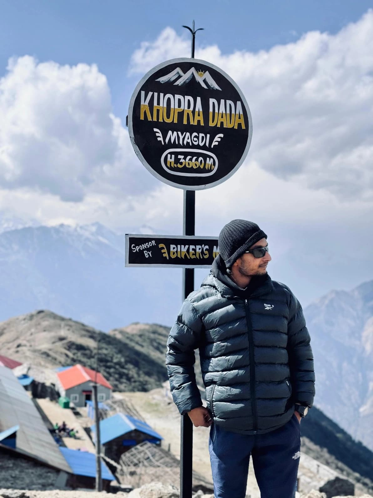
Mohare Danda is the trek I recommend to people who ask for something real but still within reach: off the main highways, culturally authentic, not overrun, and with a viewpoint that punches well above its modest maximum altitude. At 3,300m Mohare Danda ridge sits below what most people think of as high-altitude trekking — but the panorama it delivers includes Dhaulagiri (8,167m), Annapurna South, Hiunchuli, Machhapuchhre, Annapurna I through IV, and Nilgiri, spread in a single unbroken arc. Clouds often clear at dawn and dusk even when they sit lower in the valleys, making this an unexpectedly reliable viewpoint.
What makes this trail genuinely special is who runs it. Mohare Danda is a community-managed trekking corridor developed by local Magar and Gurung communities. The lodges at Banskharka, Nangi, and Mohare Danda itself are owned and operated by those villages — not by outside investors. When you sleep and eat here, the money stays in the community. The Nangi village is home to the Himanchal High School and one of Nepal's earliest rural computing programs, founded by Mahabir Pun, who is something of a legend in rural development circles.
The trail passes through rhododendron and oak forest that is genuinely dense and diverse — in March and April the ridges are crimson and pink, and birders make the trip specifically for the Himalayan Monal pheasant (Nepal's national bird), various laughingthrushes, and more than 200 recorded species in the area. I find myself moving slowly through the forest sections not because the path is difficult but because there is always something to look at.
The practical selling point that not enough operators mention is this: Mohare Danda is one of the very few treks in the Annapurna region that remains viable during the monsoon (June to September). The trail sits on a rain-shadow ridge that catches cloud and mist dramatically but rarely loses its footing in dangerous mud the way lower valley routes do. If you are in Nepal between June and September and want to walk in the mountains without the usual monsoon compromises, this is my answer.
Who this trek is for
Trekkers looking for something off the main Annapurna trails without committing to a high-altitude route. Birdwatchers, botanists, and anyone who wants to experience community-managed rural Nepal authentically will find Mohare Danda particularly rewarding. The moderate altitude (maximum 3,300m) means no serious acclimatisation concerns. It is also my first recommendation for travellers visiting Nepal during the monsoon who still want to walk in the mountains.
Best views & moments
- Sunrise from Mohare Danda ridge at 3,300m with Dhaulagiri, Annapurna range, and Machhapuchhre filling the western and northern sky
- Monsoon viability — one of the very few Annapurna trails that works June through September due to its rain-shadow ridge position
- Community-owned lodges in Banskharka, Nangi, and Mohare Danda — direct support for Magar and Gurung village economies
- 200+ bird species including the Himalayan Monal pheasant (Nepal's national bird) seen regularly in the rhododendron forest
- Nangi village's Himanchal High School and rural computing heritage — a remarkable development story in a remote community
- Dense rhododendron and oak forest on the approach ridges, spectacular in bloom March through April
- Low maximum altitude (3,300m) with no acclimatisation days required — accessible to trekkers not ready for the high passes
- Genuine off-the-beaten-path experience with far fewer trekkers than Poon Hill or Annapurna Base Camp
Day-by-day itinerary
Route & terrain
The Mohare Danda trail begins with a jeep journey from Pokhara westward into the Kali Gandaki valley, reaching the trailhead around Galeshwor or Arkhale at roughly 450-800m altitude. From there the route climbs directly upward into the Parbat and Myagdi hill country — a sustained ascent through terraced farmland giving way to oak, bamboo, and eventually rhododendron forest as you gain altitude toward Banskharka at around 1,550m.
The second day continues north through forest to Nangi, a village that is consistently the most interesting cultural stop on this route. Nangi's community-managed lodge is well-maintained and the local school is genuinely worth visiting if the timing aligns. The forest here is excellent for birding: Himalayan Monal, kalij pheasant, various babblers, and in spring, multiple warbler and flycatcher species moving through the understorey.
From Nangi the trail pushes north and upward through increasingly dense rhododendron — between 2,500m and 3,100m the forest can be so thick with bloom in March and April that the path runs through a tunnel of red and pink. The treeline gives way abruptly as the ridge crest comes into view, and the final steps onto Mohare Danda itself are one of the more dramatic viewpoint arrivals I know in the Annapurna region. The panorama is west-facing toward Dhaulagiri and north-facing toward the Annapurna massif, with Machhapuchhre's distinctive peak visible to the northeast.
The descent typically connects to the Ghorepani trail network, making it easy to combine with a Poon Hill sunrise before driving back to Pokhara from Nayapul. The full circuit covers approximately 60km of walking over 4-5 days.
General info
Difficulty & preparation
Mohare Danda is rated Moderate. The trail involves no technical difficulty and no altitude above 3,300m, which removes the serious acclimatisation concerns that dominate higher Annapurna routes. The primary challenge is sustained ascent: from the Kali Gandaki valley floor to the ridge crest involves roughly 2,800m of cumulative climbing over two days, most of it through forest on well-maintained but steep trail.
The path is not always wide or obvious — this is not the Annapurna Circuit main highway, and some sections between Banskharka and Nangi require paying attention to trail markers. The community has marked the route well but it genuinely helps to go with someone who knows the path. Footing in the rhododendron forest sections is often on roots and damp earth, which becomes slippery in rain.
For the monsoon trekker: the trail is steeper in places than a rainy-day route would ideally be, but the forest cover protects from the worst of heavy rain and the ridge sections above 2,800m are less prone to the severe leeching and trail degradation that affects lower valley routes. Gaiters and trekking poles are useful in the monsoon season.
How to prepare
Mohare Danda does not require specialist preparation. A trekker who can walk 4-6 hours per day on hilly terrain with a light daypack will manage the route comfortably. Trail running or hiking once or twice per week in the month before departure is sufficient for most fit adults.
The main practical preparation is gear for the forest conditions: waterproof boots (the trail can be muddy year-round), light waterproof jacket, and leech socks or gaiters for the monsoon season. The rhododendron forest sections hold moisture and leeches are active from May through September — they are harmless but uncomfortable to discover on your legs at lunch.
Bring a headtorch: the community lodges on the ridge do not always have reliable electricity after dark, and morning starts for sunrise require navigation of the final ridge section in the dark. A warm layer for the ridge nights is essential even in summer — 3,300m is cold before dawn regardless of season.
Permits you'll need
Annapurna Conservation Area Permit (ACAP)
USD 30 per person
Required for all foreign nationals. The Mohare Danda trail falls within the Annapurna Conservation Area buffer zone. Obtainable at the Nepal Tourism Board in Pokhara or Kathmandu.
TIMS Card (Trekkers' Information Management System)
USD 15 per person (NPR 2,000)
Required for trekking in the ACAP zone. Individual trekkers pay NPR 2,000; group trekkers pay NPR 1,000. I obtain this in Pokhara before departure.
I handle all permit paperwork as your licensed guide.
Altitude & acclimatisation
At a maximum of 3,300m, Mohare Danda sits below the altitude threshold where serious acclimatisation protocols are typically required. Most healthy trekkers will feel at most a mild headache on the first night at the ridge, which resolves with adequate hydration and rest. I still take it seriously and watch for symptoms, but this is not an altitude-risk trek in the way that Thorong La or Everest Base Camp are.
The bigger altitude variable is the rate of ascent: the trail climbs from around 450m at the Kali Gandaki valley floor to 3,300m on the ridge over two days. That rate is brisk but manageable for most people with moderate fitness. Drinking 2-3 litres of water per day from the first day upward is the main mitigation. Avoid alcohol on the first night at altitude if you are concerned about AMS symptoms.
Food & accommodation
The lodges at Banskharka, Nangi, and Mohare Danda are community-owned and genuinely good. Accommodation is simple — twin rooms with wooden beds and local blankets, shared cold-water bathrooms — but the food is some of the most honest and well-prepared teahouse cooking I have eaten on any trail. Dal bhat is the staple and it is freshly cooked, properly spiced, and usually served with local vegetable pickles and sometimes local honey.
Nangi's lodge has improved significantly in recent years and now offers hot showers heated by solar, a small library, and a common room with a wood stove for cold evenings. Mohare Danda lodge is more basic but the location is extraordinary and the kitchen is competent. None of these lodges have the menu variety of Namche Bazaar or Pokhara — bring snacks for the trail and manage expectations accordingly.
Because this is a community-run trail, I ask clients to eat at the lodge rather than bringing their own food where possible. This is the economic model the community relies on, and it is a fair one.
What to pack
Daypack with rain cover, waterproof hiking boots, light trekking poles for the steep descents, warm fleece and a light down jacket for evenings on the ridge, rain jacket, merino or synthetic base layers, quick-dry trekking trousers or leggings. A sun hat and sunscreen for the exposed ridge sections. Biodegradable soap and minimal toiletries — the lodges here have composting toilets and limited water, so low-impact sanitation is appreciated by the community.
For birders: binoculars and a compact bird guide to Nepal or the Annapurna region (the Birds of Nepal field guide by Carol and Tim Inskipp is the standard reference). Mohare Danda is one of the better birding spots in the Annapurna Conservation Area and a morning on the ridge with binoculars can turn up species that require much more effort to find elsewhere.