Quick facts
Nepal's most accessible high-altitude valley trek — Kathmandu to a glacial landscape of yak pastures, ancient gompas, and glacier viewpoints in 7-10 days, with a 5,050m summit option.
Overview
Langtang Valley is the trek I recommend for people who want a genuine high-altitude Himalayan experience without flying to the Everest or Annapurna regions. The road to Syabrubesi is a few hours north of Kathmandu, which makes the logistics far simpler than most comparably dramatic routes, and the valley itself — narrow, glacially-carved, lined with Tamang villages and yak herds — rewards the effort immediately.
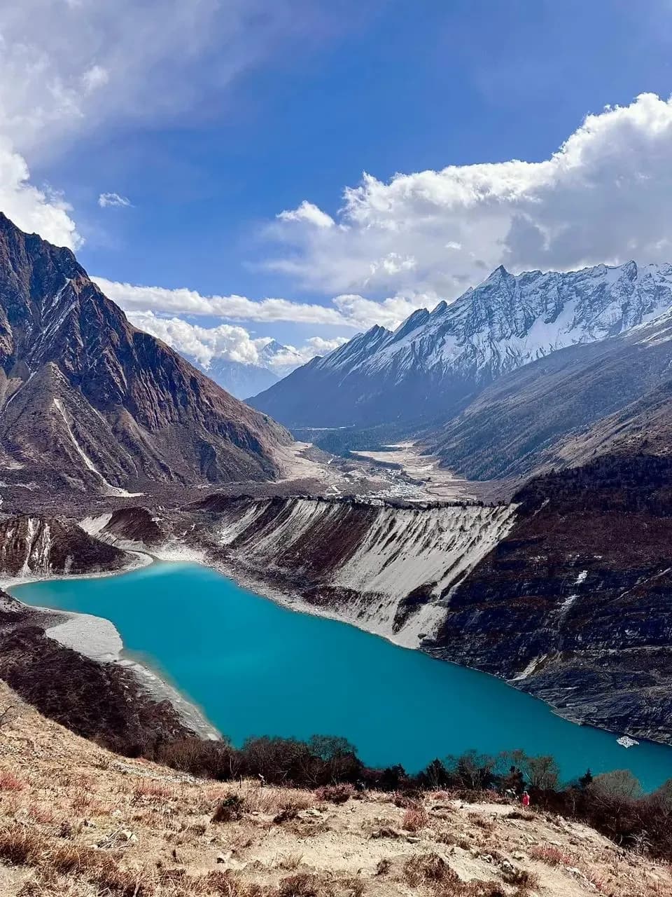
From Syabrubesi at 1,450m the trail climbs steadily through rhododendron and pine forest, past the earthquake-rebuilt settlements of Ghodatabela and Langtang village itself, to Kyanjin Gompa at 3,870m. Kyanjin is the base for everything interesting in the upper valley: the cheese factory that has been producing yak-milk products since the 1950s, the glacier viewpoint above the monastery, and — for those who want a summit day — Tsergo Ri at 4,984m, which earns a 360-degree panorama including Langtang Lirung (7,227m), Ganchenpo, and Gang Chhenpo.
I guide Langtang with particular care about the acclimatisation schedule. The altitude gain from Syabrubesi to Kyanjin is around 2,420m over three to four days — faster than ideal for some people, and I prefer an acclimatisation rest day at Kyanjin before any push toward Tsergo Ri. Since February 2025, all trekkers in Langtang National Park must be accompanied by a licensed guide. I handle all permit arrangements and the Kyanjin rest day is non-negotiable in my itinerary.
Who this trek is for
Langtang Valley is appropriate for trekkers with good baseline fitness and some prior multi-day hiking experience. The sleeping altitude at Kyanjin (3,870m) is serious enough that acclimatisation awareness matters — this is not a trek for someone who has never been above 3,000m and does not know how their body responds. For the Tsergo Ri summit at 4,984m, previous high-altitude experience above 4,000m is preferable. The logistical simplicity compared to Everest or Annapurna makes it a strong choice for a first serious altitude trek.
Best views & moments
- Kyanjin Gompa at 3,870m — an ancient monastery with glacier views and a working yak-cheese factory
- Tsergo Ri at 4,984m — a non-technical summit offering 360-degree views of Langtang Lirung, Shishapangma, and the Tibetan plateau
- The rebuilt Langtang village, a moving reminder of 2015 earthquake recovery alongside extraordinary mountain setting
- Yak herds grazing on glacial moraine under 7,000m peaks — a landscape unlike any other in accessible Nepal
- Tamang cultural villages and Buddhist gompa architecture throughout the valley
- Fresh yak cheese and butter tea at Kyanjin — a genuine local product that is genuinely excellent
- Ganja La Pass option (5,130m) linking to the Helambu region for experienced trekkers wanting a full circuit
Day-by-day itinerary
Route & terrain
The trail from Syabrubesi enters the Langtang Khola gorge almost immediately, initially through subtropical forest with mossy cliffs and suspension bridge crossings over the churning river. The valley walls are steep enough that direct sunlight reaches the trail only in mid-morning, giving the lower section a cool, shaded character even in summer. The forest transitions from subtropical broadleaf to rhododendron and pine, then to fir and juniper above 3,000m.
Past Ghodatabela the gorge opens into the broader valley that characterises Langtang above 3,200m. The 2015 earthquake destroyed much of this section — the rebuilt Langtang village and the memorials to those lost stand as reminders of what happened while the mountains above remain unchanged. The rebuilt village has good teahouses and a strong community spirit.
Kyanjin Gompa at 3,870m sits on a glacial moraine terrace at the edge of the inhabited zone. Above the monastery the valley becomes a high-altitude wilderness of moraine, ice, and boulder fields leading to the main Langtang glacier. Day hikes from Kyanjin — to the glacier viewpoint, to Kyanjin Ri at 4,773m, and for the fit and well-acclimatised to Tsergo Ri at 4,984m — are where the trek delivers its most dramatic rewards. Tsergo Ri involves straightforward scree and boulder climbing with no technical sections but demands full acclimatisation and an early-morning start.
General info
Difficulty & preparation
Langtang Valley is rated moderate, and that rating is accurate if you have some prior trekking experience and respect the acclimatisation schedule. The physical demands are not extreme — daily walking time is 4-7 hours on well-maintained trails — but the sustained altitude from Kyanjin upward (3,870m sleeping, up to 4,984m on the summit day) puts real physiological demands on the body.
The trail quality is generally good from Syabrubesi to Kyanjin, though there are sections of rough trail through boulder fields and river crossings on log bridges. Above Kyanjin, the Tsergo Ri trail becomes a sustained scree and boulder ascent with no path in sections — you are essentially walking on moraine and choosing the best line. It is not technical, but it requires good balance, a slow pace, and full acclimatisation.
The altitude gain profile is the main risk factor: Syabrubesi (1,450m) to Kyanjin (3,870m) in three to four days is aggressive. I strongly prefer four days of walking with a rest day at Kyanjin before the summit push. Trekkers who rush the ascent — which some agencies encourage — are far more likely to experience AMS. The mandatory guide requirement since February 2025 means that acclimatisation is now better managed across the board, which is a genuine improvement.
How to prepare
For a standard Langtang valley trek to Kyanjin, 6-8 weeks of aerobic conditioning is appropriate. For the Tsergo Ri summit at 4,984m, I recommend having previously trekked or hiked above 4,000m at least once — knowing how your body responds to altitude before committing to nearly 5,000m is worthwhile. Running, cycling, or swimming 4-5 days per week for 6-8 weeks provides good cardiovascular preparation.
The 2015 earthquake rebuilt sections of trail around Langtang village and Ghodatabela but the infrastructure has recovered well. Mentally, trekkers should be prepared for sections of exposed trail on the upper valley and for weather that changes quickly — clouds often build by early afternoon in the upper valley, and the descent from Tsergo Ri can be cold and windy even in October.
Consult a travel health clinic 4-6 weeks before departure for vaccination recommendations and to discuss acetazolamide (Diamox) for altitude prophylaxis if appropriate for your health profile. Langtang's altitude profile makes Diamox worth discussing with your doctor more seriously than for Poon Hill or Mardi Himal.
Permits you'll need
Langtang National Park Entry Permit
NPR 3,000 + 13% VAT = ~NPR 3,390 (~USD 27) for foreigners; NPR 1,500 + VAT for SAARC nationals
Mandatory for all trekkers entering Langtang National Park. Valid for one month from date of purchase. Obtainable at the Nepal Tourism Board in Kathmandu or at the park entry in Dhunche. I arrange this before departure from Kathmandu.
TIMS Card (Trekkers' Information Management System)
NPR 1,000 (~USD 8) when trekking with a registered agency
Mandatory for all trekkers. As of February 2025, solo/independent trekking in Langtang National Park is prohibited — a licensed guide is required. TIMS is issued through a registered agency only. I handle this as part of the pre-trek permit process.
I handle all permit paperwork as your licensed guide.
Altitude & acclimatisation
Langtang is the highest sleeping-altitude trek in this batch. Kyanjin Gompa at 3,870m is a meaningful elevation where AMS risk is genuine and must be managed actively. The ascent rate from Syabrubesi to Kyanjin — roughly 2,420m of altitude gain over three days of walking — is faster than the ideal standard of 300-500m per day above 3,000m. The acclimatisation rest day at Kyanjin is not optional in my approach.
Symptoms of AMS at Kyanjin (headache, nausea, disturbed sleep, reduced appetite) are common on the first night and usually improve with 24 hours of rest and hydration. If symptoms are not improving by the morning of the rest day, we do not attempt Tsergo Ri. If symptoms are worsening, we descend to Langtang village.
Tsergo Ri at 4,984m pushes into territory where more significant altitude effects become possible. On the summit approach, I watch for any signs of difficulty breathing at rest (possible HAPE indicator), severe headache unresponsive to ibuprofen, or ataxia (loss of coordination). These are serious warning signs and warrant immediate descent. In clear conditions with a well-acclimatised group, Tsergo Ri is an extraordinary day out. The summit views include Shishapangma across the Tibetan border, which is a reminder of how high and how far you have actually come.
Food & accommodation
The teahouse infrastructure in Langtang Valley is entirely rebuilt since 2015 and is now in good condition throughout. Syabrubesi has proper guesthouses with hot showers and reasonable comfort. Ghodatabela and Langtang village have smaller teahouses with basic facilities. Kyanjin Gompa has the best infrastructure in the upper valley — multiple teahouses, hot showers (solar at most), and a menu that includes yak cheese dishes, warm yak-butter tea, and the standard Himalayan trail menu of dal bhat, noodles, and eggs.
The yak cheese from Kyanjin is a genuine local product worth seeking out. The Swiss-established cheese factory has operated since the 1950s and produces a firm, flavourful cheese that appears in various forms on the teahouse menus. A plate of yak cheese with bread after a long morning on the trail is one of my favourite moments on this route.
All teahouses above Syabrubesi operate on a cash-only basis. Carry sufficient Nepalese rupees from Kathmandu — budget roughly NPR 2,500-4,000 per day for food and incidentals at Kyanjin altitude.
What to pack
Langtang requires warmer and more complete gear than the lower Annapurna routes. At Kyanjin (3,870m), temperatures commonly drop to -5 to -15°C on clear nights in October-November and March-April. A sleeping bag rated to at least -10°C is necessary — teahouse blankets at Kyanjin are supplementary, not primary warmth.
Key additions versus lower-altitude treks: gaiters for the moraine sections above Kyanjin, microspikes if travelling in late November or early spring when the upper trail can carry ice, a full down jacket rather than a light insulated layer, and sun protection rated SPF 50+ (the UV exposure above 4,000m is significant). Sunglasses with UV400 wraparound lenses are essential on the Tsergo Ri approach — snow reflection at altitude causes burns faster than most people expect.
For the Tsergo Ri summit attempt, carry a thermos of warm liquid from the teahouse — there are no stops above Kyanjin and dehydration at altitude progresses faster than thirst indicates. Trekking poles with wrist loops are highly recommended for the boulder-field ascent where you will use them for balance as well as propulsion.